Saturday, July 31, 2010

Forces II

Last week I went to visit a glacier, or at least a small leg of one. Svartisen is the second largest ice mass in Norway, one of the largest in Europe and while I (rightfully) expected to be impressed by the glacier itself, I could never have imagined the incredible workings of it seen on the way. I am convinced that this hike was the best experiential lesson one could have in geology. 

It is difficult to travel through Norway and not recognize that the country has been shaped by glaciers. The steep cliffs and uneven coastline quickly signal that this place did not geologically form quite in the same way or at the same time as the larger part of Europe or North America. However, it was not until arriving by boat into area cleared by a glacier within the last 100 years that I truly understood how this intense natural process works. The glacier scrapes away earth and bedrock, leaving a series of vast, uneven masses. 

Scale - there is a 6'-2" Norwegian in the photo above.

Given time after the glacier passes, water runs over the newly exposed rock surfaces, smoothing and eroding areas forming puddles, streams, and pools. Sediment turns into soil and slowly birds and insects return and the wind carries seeds which develops vegetation.

Given enough time, soil and vegetation cumulate and become the more typical landscape that Norway is noted for.


Oh, and before I forget.. Here is that little glacier arm that has caused (and continues) all of this-

Tuesday, July 20, 2010

Forces of Nature

This was a tree which once stood strong in a forest. Its former part of the forest has been cleared in a way that no machinery ever could.


Last winter, the (now) seemingly gentle waterfall in the picture above began to freeze. Ice collected and created a type of dam which lasted until a warm day in April. With temperatures around 70 degrees (F), the waterfall gained power from the melting snow at its source. Simultaneously, the ice dam weakened in the sun until the water was able to explosively push through. The power from it prevented the water volume from following the usual river path (which curves to the right of this photo). The rush of the water alone, with the debris and rock carried by it, shredded trees and a telephone pole in its new path. The result was stunning in the demonstration of shear force.

These photos were taken in June, and under the soil there were still mounds of ice and snow amongst the forest debris. (Virvasdalen, Nordland, Norway)


Friday, July 9, 2010

Natural Reclamation


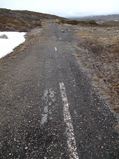
A little eerie, but somehow simultaneously heartwarming and reassuring - the land in this picture was a major highway just 20 years ago. In fact, this stretch used to be part of the E6 - the only main traffic route through northern Norway - where it crosses the arctic circle. 


On top of the harsh weather conditions associated with this latitude (there were still spots of snow in mid June), this area also falls on a mountain at rather high altitude for Norway. The tree line in Norway is low - falling around 300 m (or 1200') above sea level for the south, and becoming much lower (down to 100m or lower) as one progresses to the north. The remaining barren landscape exposes the ground to strong winds and snow drifts through the roughly 6 month winter, so locating (and maintaining) road and rail lines becomes a difficult task. In some sections near here, long sheds have been built over the railway to shelter from intense winter drifting. The area is also bisected by many streams which ebb and rage during periods of snow melt, threatening complete wash-outs for the line of infrastructure. After repeated washouts and snow problems, it was determined to move the highway and the Polarsirkelensenteret (arctic tourist visitor's center) east of the original location. 

Landscape at 66.56 degrees latitude with arctic circle center and markers.


Today the vacated highway is being reclaimed by the nature around it - and quite rapidly at that. The open landscape and former infrastructure is open to hikers (and grouse hunters) who can actively see the restoration of habitat taking place. We found a nest of eggs from a bird known in Norwegian as Heilo - the Eurasian Golden Plover (http://en.wikipedia.org/wiki/Eurasian_Golden_Plover) - camouflaged but out in the open landscape maybe 15 feet off the old road - the current infrastructure far beyond. 


The train crossed our path before our return to the visitor's center - allowing an informative shot of the infrastructure - the rail line following the river, with the current highway in the background.