Thursday, August 26, 2010
The Intentional and Unintentional Skate-park
Friday, August 20, 2010
Connected..
I read a blog a few weeks ago wherein the author held a firm stance that it is impossible to go 'off the grid' in this day and age (http://www.infrastructurist.com/2010/07/29/is-it-possible-to-go-truly-off-the-grid-a-guest-post/). It was a good reminder of everything 'the grid' encompasses, and the fact that whether we realize it or not, we are all connected. There are services we share as a society - whether you are living 'remotely' in the countryside off a long driveway or in a dense city where you see your neighbors every day. What strikes me as interesting is that with all we share, why is it so difficult for western society to identify with the concept of communal resources. Is it because our electric wires and sewer systems are buried underground, or is it simply that the road has been there so long we forget that it belongs to all of us?
Now that I am returning to city life I will continue to ponder this and wonder how it is that we designers might be able to exploit the communal-ity of infrastructure and help residents understand the connections that make their (local) world work. And further, to help us remember that the most important systems we need to deliver the resources we live from are not only the man-made technological ones, but also those natural ones which we so often take for granted.
Saturday, July 31, 2010
Forces II
It is difficult to travel through Norway and not recognize that the country has been shaped by glaciers. The steep cliffs and uneven coastline quickly signal that this place did not geologically form quite in the same way or at the same time as the larger part of Europe or North America. However, it was not until arriving by boat into area cleared by a glacier within the last 100 years that I truly understood how this intense natural process works. The glacier scrapes away earth and bedrock, leaving a series of vast, uneven masses.
Scale - there is a 6'-2" Norwegian in the photo above.
Given time after the glacier passes, water runs over the newly exposed rock surfaces, smoothing and eroding areas forming puddles, streams, and pools. Sediment turns into soil and slowly birds and insects return and the wind carries seeds which develops vegetation.
Given enough time, soil and vegetation cumulate and become the more typical landscape that Norway is noted for.
Oh, and before I forget.. Here is that little glacier arm that has caused (and continues) all of this-
Tuesday, July 20, 2010
Forces of Nature
This was a tree which once stood strong in a forest. Its former part of the forest has been cleared in a way that no machinery ever could.
Last winter, the (now) seemingly gentle waterfall in the picture above began to freeze. Ice collected and created a type of dam which lasted until a warm day in April. With temperatures around 70 degrees (F), the waterfall gained power from the melting snow at its source. Simultaneously, the ice dam weakened in the sun until the water was able to explosively push through. The power from it prevented the water volume from following the usual river path (which curves to the right of this photo). The rush of the water alone, with the debris and rock carried by it, shredded trees and a telephone pole in its new path. The result was stunning in the demonstration of shear force.
These photos were taken in June, and under the soil there were still mounds of ice and snow amongst the forest debris. (Virvasdalen, Nordland, Norway)
Friday, July 9, 2010
Natural Reclamation
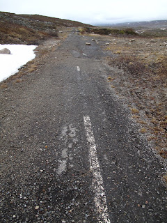
A little eerie, but somehow simultaneously heartwarming and reassuring - the land in this picture was a major highway just 20 years ago. In fact, this stretch used to be part of the E6 - the only main traffic route through northern Norway - where it crosses the arctic circle.
On top of the harsh weather conditions associated with this latitude (there were still spots of snow in mid June), this area also falls on a mountain at rather high altitude for Norway. The tree line in Norway is low - falling around 300 m (or 1200') above sea level for the south, and becoming much lower (down to 100m or lower) as one progresses to the north. The remaining barren landscape exposes the ground to strong winds and snow drifts through the roughly 6 month winter, so locating (and maintaining) road and rail lines becomes a difficult task. In some sections near here, long sheds have been built over the railway to shelter from intense winter drifting. The area is also bisected by many streams which ebb and rage during periods of snow melt, threatening complete wash-outs for the line of infrastructure. After repeated washouts and snow problems, it was determined to move the highway and the Polarsirkelensenteret (arctic tourist visitor's center) east of the original location.
Landscape at 66.56 degrees latitude with arctic circle center and markers.
Today the vacated highway is being reclaimed by the nature around it - and quite rapidly at that. The open landscape and former infrastructure is open to hikers (and grouse hunters) who can actively see the restoration of habitat taking place. We found a nest of eggs from a bird known in Norwegian as Heilo - the Eurasian Golden Plover (http://en.wikipedia.org/wiki/Eurasian_Golden_Plover) - camouflaged but out in the open landscape maybe 15 feet off the old road - the current infrastructure far beyond.
The train crossed our path before our return to the visitor's center - allowing an informative shot of the infrastructure - the rail line following the river, with the current highway in the background.
Tuesday, June 29, 2010
Taming Wilderness
(Bredek farm is top, center in the distance)
The answer turned out to be fairly simple - at the time, the farmland in the valley served by roads was running short, so farmers were forced upland and into remote areas to establish fields and grazing pastures. Along with this, I can only imagine, came a heavily work-ridden life removed from society around. The alternative option or next step in this migration turned out to be the expensive and arduous move to America where accessible, flat land was still plentiful.
Above is one of the first fields found on approach to Bredek. The stone wall is as old as the cultivation - having been built from the rock found when clearing the land. The full farm follows, with much of the older equipment still intact - from wooden sickles to steel wood stoves which must have been hauled to the site. The farm's environment and site is exquisite in nature with the views to the mountains, shelter from strong winds, natural water sources and constant reassuring sounds of a nearby waterfall and the woods full of birds and wildlife.

Two-thirds of the way back, spotting the highway and railroad infrastructure below, the remoteness really sank in.
The concept of living off the land, and the very real proof that this earth does not hold the capacity for everyone to do just that today. The need for cities and densities becomes clear, but how do we reconcile this with man's desire for space and yearning for natural surroundings. My very presence in this place seems to bring the story full circle without quite answering any of the questions. Settlers moved from Europe to the New World for land and opportunities, built cities far removed from farming sensibilities and nature, and bred a generation of assorted urbanites - some of whom, like myself, now seek a break from the stifling city life to better reflect on its problems only to find that perhaps we simply end up back where we started.